
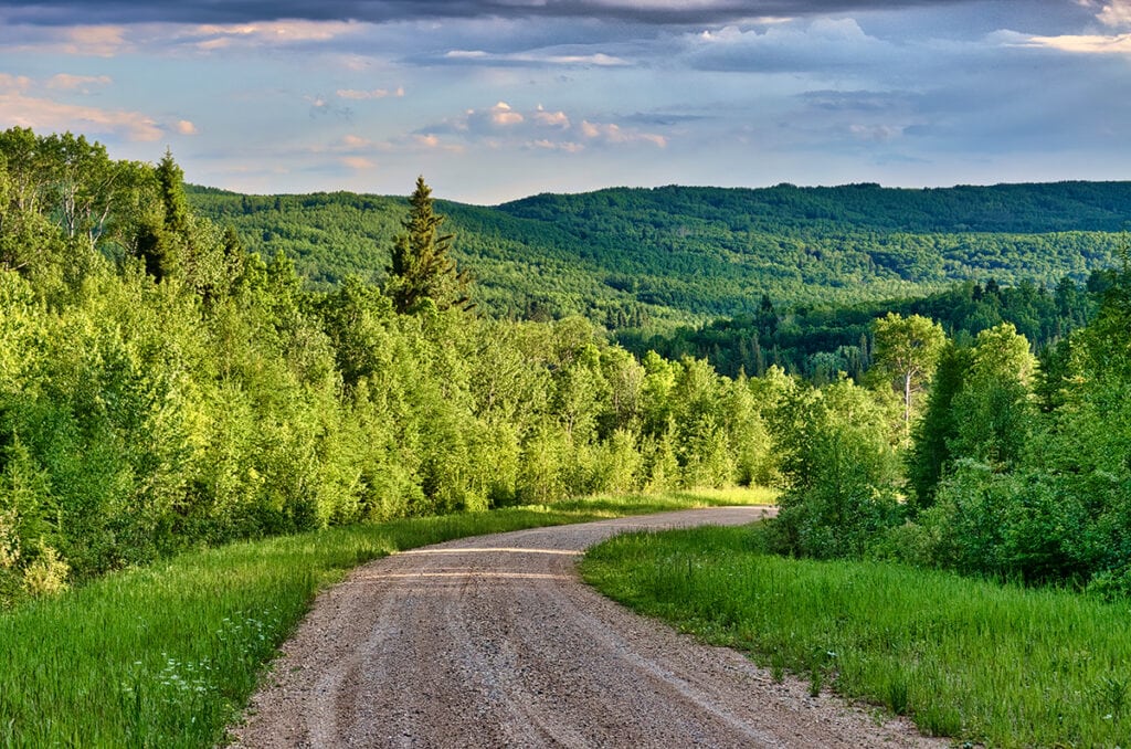
The Duck Mountain Highlands straddle the Saskatchewan/Manitoba border. They are remarkable for having some of the most southerly boreal forest wilderness in the Prairies. Surrounded mostly by farmland, these hills remain a wild oasis cloaked with dense forest, numerous lakes and wetlands, valley meadows, and wildlife such as black bears, moose, deer, lynx, coyotes, and wolves.
Some 15,000 years ago, massive ice fields more than three kilometres thick were melting, pooling their waters into enormous glacial-fed Lake Agassiz. Along the western edges, ridges developed into the uplands that we see today.
Both Saskatchewan and Manitoba have a Duck Mountain Provincial Park to protect the environment and provide some outstanding recreational possibilities.
The best part is that we can take a scenic road trip loop combining the highlights of the parks in both provinces, including the highest point of elevation in Manitoba. Along the way, we also visit the mind-boggling Swan River Magnet Hill where you won’t believe your eyes as your car rolls uphill.

The park lies roughly 400 kilometres east of Saskatoon, or 300 kilometres northeast of Regina. After we leave the eastern Saskatchewan town of Kamsack, the terrain suddenly changes from farmland to thick hilly forest as we climb around 240 metres to the park. The climate changes as well – cooler than the plains below and with higher precipitation.
Highway 57 runs through the park and continues into Manitoba. Madge Lake is the park’s centrepiece, with popular Ministik Beach, a park visitor centre, and other amenities such as picnic sites, trailheads for hikes, a golf course, and accommodation.


Pickerel Point Campground, the largest in the park, stretches along a peninsula of Madge Lake, a bit farther east along Highway 57. However, our go-to place to camp is the small Fern Campground, along the lakeshore just east of Ministik Beach. It doesn’t have services such as electricity but the compact size and more quiet and secluded setting make it a pleasant spot.
If you like backroad exploring, take a drive on the Old Park Road. As the name suggests, this was the road to the park before Highway 57 was built. To get there, head west along the shore of Madge Lake. Before long we pass the trailhead for the Pelly Point Trail, a 4.4-kilometre loop walk to a peninsula jutting into Madge Lake, featuring old-growth forest with massive trees, marshes, and fern meadows.
The Old Park Road starts near the trailhead. Since the road is not maintained, it’s probably best to avoid in wet conditions. The narrow road weaves through the forest and beside several small lakes. You pass the trailhead for the Green Lake Trail, considered a moderately challenging hike of 13 kilometres return. When you leave the west side of the park, take any gravel grid road heading south to Highway 57.


Our favourite drive is the 12-kilometre Ski Hill Road, heading to the southern reaches of the park near a ski hill and ending in Little Boggy Creek Valley. It starts off Highway 57, just east of the park’s core area. Near the first part of the drive, watch for wildlife such as deer, beaver, and a variety of birds at wetlands on both sides of the road. The park is noted for having a high loon population.
The road passes a pleasant picnic site at Batka Lake then before long starts descending with some exceptional views across the hills and valley. While scenic anytime, the fall colour season can be breathtaking due to the wide mix of trees in the forest.
 in the Duck Mountain Highlands." width="1024" height="680" />
Watch for a minor access road that leads to Little Boggy Creek, a beautiful spot that we visit each time we come to the park. Marsh marigolds thrive along the creek edge in spring, while nearby open meadows host an array of multicoloured wildflowers. As a bonus, this area gets relatively few visitors.
A definite highlight is the Fen Trail. The short trail along a boardwalk crosses a calcareous fen, with sedges, grasses and pools of stagnant water. Interpretive signs explain the workings of a fen and the wildlife and rare plants it supports. Most intriguing are carnivorous plants such as butterworts and oblong-leaved sundews that trap insects and even tadpoles.

Follow Highway 57 east as it continues into Manitoba. Almost immediately after crossing the border, turn north onto Highway 83 towards the town of Swan River. Just after Benito, the highway turns east. From this corner keep going north then west, following the signs to the Thunder Hill Ski Area which is almost smack on the Manitoba/Saskatchewan border. We cross the picturesque Swan River Valley on the way.
Just before the ski hill, the road goes downhill (at least it looks that way) before arriving at the sign for the Swan Valley Magnet Hill. We followed the instructions on the sign which said to stop, put your vehicle in neutral, and then release the brake. Almost instantly we started rolling backwards, seemingly uphill!

It’s all an optical illusion rather than there being a gigantic magnet somewhere. Because of the lay of the surrounding terrain, our brains get fooled into seeing an upward slope as being down. But even with a logical explanation, this place still left us scratching our heads in disbelief.
This anomaly occurs in a few other places, but it is thought to be the only one in the Prairie Provinces. The most famous is Magnetic Hill in New Brunswick which has become a huge tourist attraction. But here you won’t have to contend with line-ups or admission fees. You’ll likely have the place to yourself, so try it a few times if it feels like you’re hallucinating.
To continue on the route, head straight east from Magnet Hill, eventually meeting Highway 83 just south of Swan River. The largest community in the area, Swan River is the ideal place to pick up supplies for a visit to Manitoba’s Duck Mountain Provincial Park. Don’t miss the huge statue of a swan and the floral displays in front of the Visitor Centre.

To get to the park, head east of town on Highway 10, then south on Highway 366 which runs the length of the park. Farmland around Swan River soon gives way to thickly forested highlands and seemingly endless lakes and wetlands.
A worthwhile stop right beside the road is the Duck Mountain Forest Interpretive Centre. A self-guided display introduces the forest landscape, plus there’s a picnic site and some short hiking trails.
Shortly after entering the park, we come to Wellman Lake, the first of three major recreation areas with facilities such as campgrounds, accommodations, and trailheads. The other two are Blue Lakes in the centre and Childs Lake in the west. There is also a small campground at Singuish Lake to the east along Highway 367.
Between these recreation areas, the park has a remote off-the-beaten-path feel to it, not surprising since the Manitoba side is close to ten times the size of its Saskatchewan counterpart. The roads are all gravel but in good condition. What struck us most was the sheer number of lakes. Many have boat access and even post signs as to fish species you might catch. While fishing is a big draw, there are also canoe routes and trailheads for several hikes.

Our favourite part of the park was the Blue Lakes. Before arriving we wondered why they couldn’t come up with a more imaginative name. After all, aren’t all lakes blue? But once there it became obvious. This was blue taken to another level – a brilliance we are more likely to see in the Caribbean than in a forest lake. The hue changes with the angle of the sun and at times it appears more emerald green.
It has to do with the depth of the lakes and the incredible clarity. Considered one of the clearest lakes in Manitoba, 60-metre-deep East Blue Lake has become a hot spot for scuba diving.


Of the many hikes in the park, we enjoyed the Blue Lakes Trail, a 5.5-kilometre loop along the adjoining East and West Blue Lakes shoreline. It’s a great chance to see the changing hues of the shimmering blue water. From the same trailhead, we also walked the popular yet short one-kilometre Shining Stone Trail that circles a peninsula jutting into West Blue Lake.
We chose the Blue Lakes Campground for our stay. If you’re tenting, try to snag one of the nice walk-in sites close to West Blue Lake. The trailhead for the Blue Lakes Hikes is just a short stroll away.

Just south of the Blue Lakes, we come to Highway 367 to head west to continue our loop trip. But before doing that, keep going south along Highway 366 to visit Baldy Mountain near the south end of the park. This is the highest elevation point in Manitoba at 831.2 metres, and we can drive to the top. While it is heavily forested now, early settlers called it Baldy because fires had burned it bare.
Climbing the viewing tower helps us to get above the trees and see how the land suddenly drops to the plains just to the south. The Baldy Mountain Trail is a nice 3-kilometre loop walk down the hilly slopes. Part way down is an old ranger’s cabin and stable dating to the 1920s.
Highway 366 continues south out of the park, soon reaching the town of Grandview on Highway 5 about 47 kilometres west of Dauphin. This would be the best route to take if you want to start your visit from the Manitoba side.
To continue the loop drive back to Saskatchewan, return to the junction with Highway 367 and head west passing even more lakes and hiking trails. One even has the official name of Beautiful Lake. Childs Lake along this stretch has the largest campground in the park. The 4.1-kilometre Child’s Lake Trail starts in the campground and follows the lakeshore then loops back through the forest. Continuing west, the road eventually meets Highway 83 close to the border with Saskatchewan.

Want More Things to Do in the Area?
While Duck Mountain Provincial Park in both Manitoba and Saskatchewan are amazing places to explore, there’s so much more to both provinces. For more travel ideas, check out these guides below:
Robin and Arlene Karpan are award-winning writers, photographers, bloggers, and book authors. Their work has appeared in over 100 publications around the world. Their popular blog photojourneys.ca, which looks at travel from a photographer’s perspective, has been rated among the Top 100 Travel Photography sites by Feedspot. Robin and Arlene have a special interest in capturing the beauty of Canada’s magnificent and diverse landscapes.
This site uses Akismet to reduce spam. Learn how your comment data is processed.